At the beginning of the 20th century the landscape of Oldbury was marked by remarkably huge holes in the ground. As Dr Terry Daniels puts it, ‘Once the coal had gone, they were left with the marl. The area around Rounds Green was a mass of marl holes and brickworks, spoil heaps, pit heads left... ’
In ‘Oldtime Oldbury’, edited by Terry, Wilf Walters shared this memory: ‘Sadler’s Brickworks was located in the area bordered by Shidas Lane, Portway Road and Taylors Lane. The one on the other side of the road was always used by Accles and Pollocks as a waste tip. When I was a lad there was no fence around it, just the Rounds Green Road and the marl hole was in action when I was a little boy. The people of Rounds Green used to walk round there and throw their rubbish into the marl hole - it was a common tip. William Whitehouse was the general office manager at Sadler’s. He was a cripple with a clump foot, a big shoe on one foot. In the main it was ladies that made the bricks, with big sacking aprons on. I can see them now with skirts down to their ankles and great pieces of sacking on, knocking heavy lumps of clay into the box moulds.’
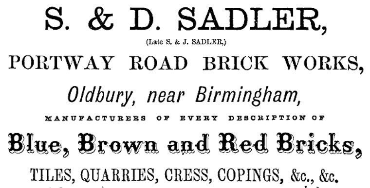
John Sadler first worked as was a carpenter and builder. In 1847 he registered the John Sadler & Sons Company of Shidas Lane, Oldbury and developed a site covering seven acres. The bricks were made from the local red clay, Etruria marl, which contained a high proportion of iron-bearing minerals. When fired at a high temperature and in a low oxygen reducing atmosphere, these minerals took on a deep blue colour, producing a brick with a hard wearing impervious surface. The clay was extracted, then milled, ground and mixed with water to a plastic mass. It was shaped, cut and dried; then it would go to a kiln, fired over a number of days, taken out and stacked, to be transported on a boat along the Portway canal arm.

Mabel Stewart describes a photograph from 1932:
“That’s my mother in front of their house, Jim, Dora and Edith – it was on loan to them from Saddlers. My Grandad used to be the foreman there. He was in charge of the blasting. They’d dig out clay for bricks. My Mom used to have to take his dinner down to him. They had a little wagon that used to go up and down the marl hole and take stuff to the men in the bottom in ‘The Hod’, that’s what they called it. She said it was just a shed. When they blasted, he’d blow a whistle and they all went in the shed, because he was about to light the dynamite. She had a billycan with his tea and she used to scrabble halfway down and then there’d be some cursing and swearing from the men down in the bottom in case she was hit from the blast, because she really should have put it in the wagon to send down.
The whole house eventually slid into that pit. The blasting caused it all to subside, so the family had to all move out. Mom was about 11 then. She said you couldn’t go out the back door, it was boarded up - because outside all there was left was just the tip. The front wall remained there with the letterbox on it for many, many years after the house went down the marl hole.’
- extracted from ‘Old-time Oldbury, Photographs and Memories’, collated by Terry Daniels, Oldbury Local History Group, 2000.
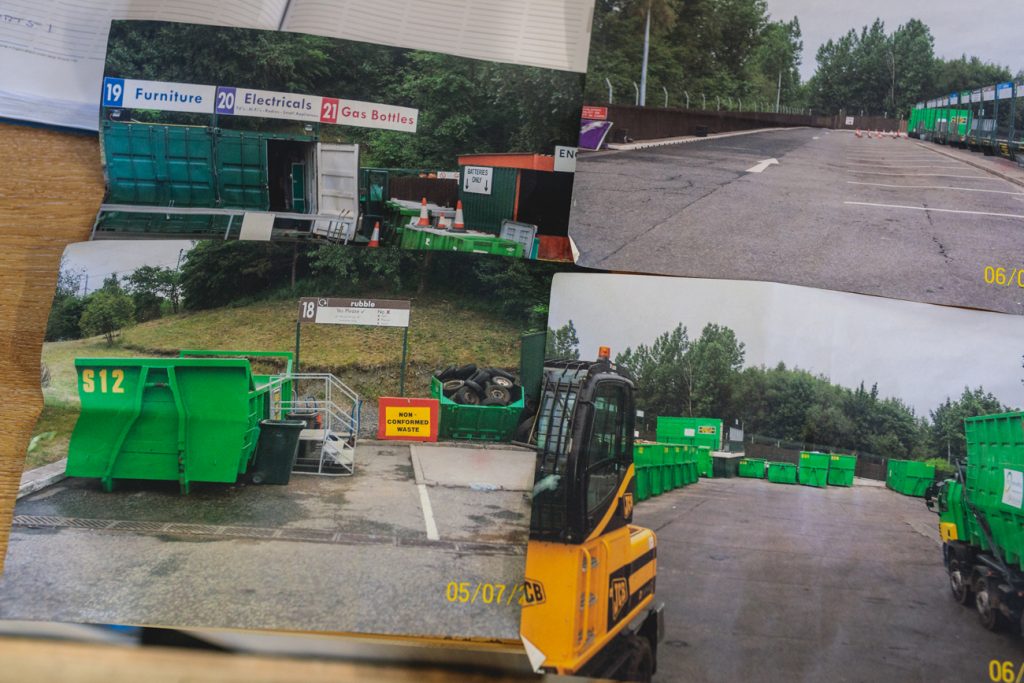
The marl hole was exhausted in the 1940s. It was finally filled in the 1970s, the land reclaimed and is today used as the council’s refuse depot - Shidas Lane. The instability of the ground made it unsuitable for housing.


Across the road from the refuse tip are further reminders of the industrial waste of the past. This photograph below from 1966 (by J. Tustin), taken along Portway Road towards Churchbridge, shows the demolition of one of the spoil banks and marl hole. At the time of filling in, it measured some 700 yards by 390 yards at ground level. There were two pools here, the largest was contaminated and when pumping started the water was 70 feet deep. In the smaller pool the water must have been sweet as it was teeming with fish. These were netted, placed in tanks and hurried off to the River Severn where they were released. Once the ground settled this area was used for building an electricity substation.

This photograph from 1966 (by J. Tustin), taken along Portway Road towards Churchbridge, shows the demolition of one of the spoil banks and marl hole. At the time of filling in, it measured some 700 yards by 390 yards at ground level. There were two pools here, the largest was contaminated and when pumping started the water was 70 feet deep. In the smaller pool the water must have been sweet as it was teeming with fish. These were netted, placed in tanks and hurried off to the River Severn where they were released. Once the ground settled this area was used for building an electricity sub station.
Related pages